 |
||||||||||||||||||||
|
|
||||||||||||||||||||
|
Except as otherwise noted, all material on this website is copyright, 1997 to 2015. |
||||||||||||||||||||
|
Website visitors since 15/1/03 |
||||||||||||||||||||
|
|
||||||||||||||||||||
|
THIS MAP IS CLICKABLE. JUST CLICK ANY OBJECT (WHERE POINTER BECOMES A HAND) TO GO TO THE RELEVANT WEBPAGE OR SITE. |
||||
|
The settlements of the Durris area are widely scattered and include Craiglug, Woodlands of Durris, Denside of Durris, Kirkton of Durris, Crossroads, Blairydryne, Lochton and Da Click here for the early history of Durris. The church dates from 1822 and has a Fraser Burial Aisle which dates, in part, from 1587. Click here to see details (on Amazon) of a book about the Durris Kirkyard. The local primary school ( Durris Primary 01330 811457) is at Woodlands of Durris. Much of the area of Durris is covered by Durris Forest. This precious resource is cared for by the Friends of Durris Forest. Durris contains about 495 electors and 252 households. |
||||
|
The historic Kirkton Old Bridge is in danger of collapse - for further information, click here. |
||||
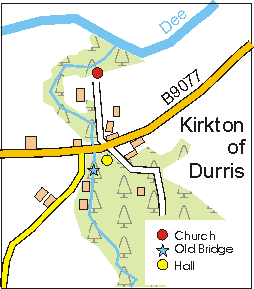 rnford. The most substantial of these is Kirkton of Durris, shown in the map (left).